Without further introduction, 8 conceivably useful applications of Google’s new Street View:
- Find parking before you get in the car.
- Find a store’s hours
- Check if you can pay by credit card (courtesy of Damon Kohler).
- Look up a phone number
- Thinking of moving? Check out the neighborhood. Maybe you’ll find it a bit out of your price range.
- Can I sit while I wait for the bus?
- Will I be out of the rain while I wait for my bus?
- Should I bring loose change for the parking meter?
(Ok, so some of those are pushing it a bit. If I’m optimistic, I can see how this could become very useful, instead of just being used to spy on housecats.)
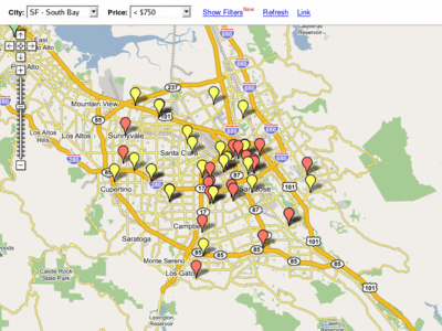
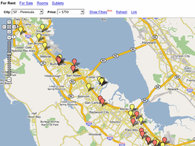
http://www.housingmaps.com/ is basically Google maps + Craigslist. Cool use of Google maps. Since it lets you pick a price range, it is super easy to make animated maps, showing the distribution of both affordable and luxury housing. Here’s one of downtown San Jose:
and one further up the peninsula:
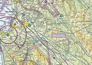
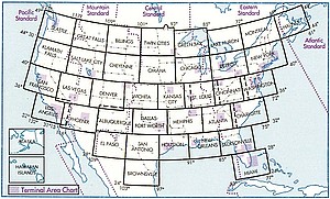
Flying in flight simulator just doesn’t seem right without sectional charts. I looked around for somewhere to get them, but didn’t find anything great. Paper charts are available but they are expensive if you want a wide area of coverage. There are some other digital charts, like the ones uploaded to the AVSIM file library by Matt Fox, but they aren’t available in one package. So I started with the excellent collection available at aviationtoolbox.org and made my own set.
This package includes sectional charts covering the entire US including Alaska and Hawaii. Also included are all the Terminal Area Charts, which show more detail around large airports. These are the same charts that pilots use for VFR flights. Hopefully they will make your flight simulator experience a little more realistic and enjoyable.
I suggest downloading a browser plugin like FSBrowser or FSX-ionals to view the charts in-flight. (An exciting project to keep an eye on is FSM MovingMap. Matt Fox’s maps work with this moving map software. Unfortunately, the maps in this package don’t because FSM MovingMap does not yet support the projection they use and I didn’t bother to convert the geocoding information.)
I’m putting these up under a Creative Commons license. Check out the readme for details. The download is about 500 Mb, so I’m using BitTorrent to distribute it. The hosting is being done through LegalTorrents, which offers free BitTorrent hosting for content under a Creative Commons license.
Download sectional charts (You need to have a BitTorrent client to download this.)